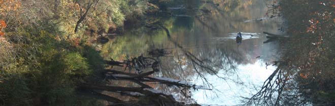
The following river flow graphics are produced by the National Weather Service's "Advanced Hydrologic Prediction Services (AHPS)". If flooding is expected, the graphics will show forecasts of expected river flow and stage. If no flooding is expected, the graphics will show observed flows and stages for the past few days. The graphics are updated at least once each day, and may be updated more frequently during flood periods. (If you visit this page frequently, be sure to use the "Refresh" button on your browser to be sure you are seeing the latest graphics.)
|
|
|
|
|
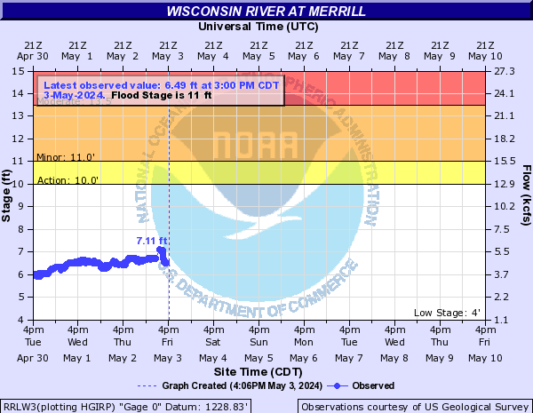
NWS Flood Impacts for Wisconsin River at Merrill |
| Stage |
Impacts |
|
18.0' |
7.0 feet above flood stage...significant flooding is occurring in the Merrill area. This includes the sewage disposal plant is flooded...area parks and lowland is flooded...and the western approach of highway 64 bridge is covered with water |
|
16.0' |
5.0 feet above flood stage...area parks and lowland in the Merrill area are flooded. The west approach to the highway 64 bridge becomes flooded |
|
13.0' |
2.0 feet above flood stage...there is flooding of Merrill area parks and lowland. The water touches the base of the river gaging station |
|
11.0' |
At flood stage...flooding mainly affects Merrill area parks and agricultural land |
|
10.0' |
At bankfull stage...there is minor lowland flooding. Flood stage is at 11 feet |
|
| Top |
|
|
|
|

|
|
NWS Flood Impacts for Wisconsin River at Rothschild |
| Stage |
Impacts |
|
29.0' |
4.0 feet above flood stage...water affects at least one business and parts of business highway 51. The river banks in this area are steep sided. Most homes and roads are well above record flood levels |
|
28.0' |
3.0 feet above flood stage...water affects business highway 51 and one business in Rothschild |
|
25.0' |
At flood stage...a public boat landing on the west side of the river is covered with water |
|
23.0' |
2 feet below flood stage...water touches the base of the river gaging station and their is minor lowland flooding |
|
18.0' |
At bankfull stage...there is minor lowland flooding. Floodstage is at 25 feet |
|
| Top |
|
|
|
|

|
|
NWS Flood Impacts for Wisconsin River at Wisconsin Rapids |
|
Stage |
Impacts |
|
12.0' |
At flood stage...water is near a building at the intersection of 2nd Avenue and Gaynor Avenue. Playground equipment in Lions park is surrounded by water |
|
10.0' |
At bankfull stage...water covers walkways in Lions Park in Wisconsin Rapids. Flood stage is at 12 feet |
|
| Top |
|
|
|
|
|
|
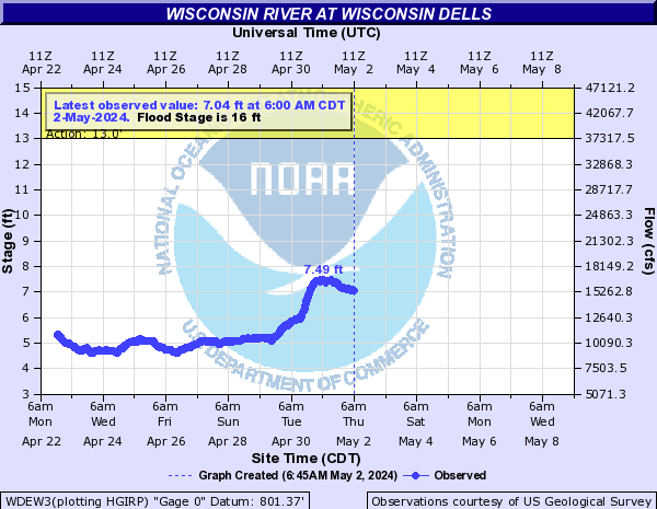
NWS Flood Impacts for Wisconsin River at Wisconsin Dells |
| Stage |
Impacts |
|
17.6' |
Floodwaters affect roads in Sauk County adjacent to the river. This level is considered to be about a 10 year flood. |
|
17.0' |
Floodwaters affect cabins and trailers along Levee Road, Van Hoosen Road and Indian Trail Parkway in Sauk County. |
|
16.0' |
There is flooding to agricultural land and wooded land. |
|
15.0' |
There is minor lowland flooding. This level is considered to be between a 2 year flood and a 5 year flood. |
|
14.0' |
There is minor lowland flooding. This level is considered to be between a 2 year flood and a 5 year flood. |
|
13.5' |
There is minor lowland flooding. This level is considered to be about a 2 year flood. |
|
13.0' |
There is minor lowland flooding. |
|
| Top |
|
|
|
|
|
|
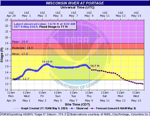
NWS Flood Impacts for Wisconsin River at Portage |
| Stage |
Impacts |
|
21.4' |
This level is about a 100 year flood. |
|
20.9' |
This level is about a 50 year flood. |
|
20.0' |
This level is about a 25 year flood. |
|
19.2' |
This level is about a 10 year flood. |
|
19.0' |
The U.S. Army Corps of Engineers is mobilized. |
|
18.5' |
The levees in the Portage area are monitored and patrolled. |
|
18.2' |
This level is about a 5 year flood. |
|
18.0' |
There is evacuation of the residents of homes in the Blackhawk Park area. |
|
17.0' |
There is general overflow of the river and water is near homes in the Blackhawk Park area of Portage on the west side of the river. |
|
16.0' |
There is minor lowland flooding. |
|
| Top |
|
|
|
|
|
|
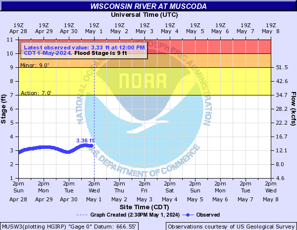
NWS Flood Impacts for Wisconsin River at Muscoda |
| Stage |
Impacts |
|
13.8' |
The river reaches the low steel on the Highway 80 Bridge over the river. |
|
11.0' |
Widespread lowland flooding is likely... but the town of Muscoda should remain above the flood waters. |
|
10.0' |
There is extensive lowland flooding... however no flooding has been reported in Muscoda in previous years. |
|
9.0' |
The river begins to go out of its banks in some locations... with only minor flooding. |
|