|
 -
General Description -
General Description
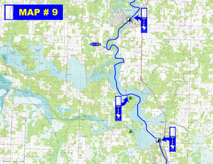
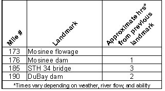
o Miles 173 - 176 (Mosinee flowage to Mosinee dam) Maze-like Mosinee
flowage is filled with many small islands and it is easy to temporarily
get off course
o Miles 176 - 185 (Mosinee dam to STH 34 bridge) River starts out
with noticeable current with some sharp bends before the Eau Pleine
Reservoir empties in on the right marking the upper end of Lake
DuBay
o Miles 185 - 190 (STH 34 to DuBay dam) The river spreads out considerably
into 6,830 acre Lake DuBay with much recreational activity and turbulent
conditions on windy days
- Portages (see portage maps by clicking on the dam symbol)
o Mile 176 Mosinee dam - A telephone is provided attached to an
informational sign at the portage for assistance provided by Mosinee
paper. Be prepared for about a 45 minute to 1 hour wait. To call
ahead from any phone dial (715)692-3304 to plan for a shuttle OR
a portage route of just over 1 mile goes through Mosinee (take-out
on left, put-in on right)
o Mile 190 DuBay dam - Take out at the marked sandy beach just upstream
of the DuBay dam to a 750' portage that ends with a steep descent
into the tailwater (left)
- Landings suitable for take-out or put-in
o Mile 176 - River Park boat landing to access above the Mosinee
dam (right)
" Chuck's Landing on Fremont St consists of two boat landing
areas with parking provided to access below the Mosinee dam (right)
o Mile 179 - Beans Eddy Road boat landing (right)
o Mile 185 - SeaGull Lane boat landing (left)
" Lilac Road boat landing (right)
o Mile 189 - DuBay County Park boat landing (right)
o Mile 190 - Old Hwy 51 boat landing to access above the DuBay dam
(left)
" Landing at DuBay powerhouse to access below DuBay dam (right)
(More access sites available on Lake
DuBay )
- Camping
o Mile 185 Private campground - "Lake DuBay Shores (715-457-2484)"
(right)
o Mile 189 Portage County - DuBay
Park with 31 sites (right)
- Other amenities
o Mile 176 - Many businesses in Mosinee
" River Park in Mosinee with boat landings, picnic area with
shelter, playground and fishing pier (right)
o Mile 189 - DuBay County Park with boat ramp, large picnic area
with shelter, playground, swimming beach, and ball field (right)
(Additional private restaurants & marinas on Lake DuBay not
listed)
- Flow Information - For flow information on river flow below DuBay go to http://www.cwpco.com/CWPCoDB/Daily_River_Report.aspx.
|