|
 -
General Description -
General Description
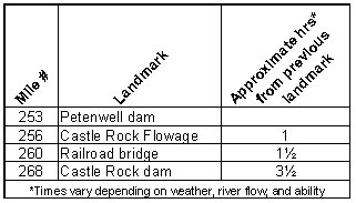
o Miles 253 - 268 (Castle Rock Flowage)
16,640 acre Castle Rock Flowage is the fourth largest inland body
of water in Wisconsin. Individuals must use extreme caution; the
flowage is relatively shallow and quickly becomes turbulent on windy
days.
- Portages (see portage maps by clicking on the dam symbol)
o See MAP #13 for Petenwell portage and MAP #15 for Castle Rock
portage
- Landings suitable for take-out or put-in
o Mile 257 Osprey Landing (right)
o Mile 261 Mays Point boat landing (right) Little Roche a Cri boat
landing (left)
o Mile 265 Snug Harbor boat landings (left) Adams County Castle
Rock Park boat landing (left)
o Mile 265 Germantown Park boat landing and O'Dells Bay Public Marina
both located on the west side of the Yellow River arm of the flowage
(right)
o Mile 267 Juneau County Castle Rock Park boat landing (right)
(For a Wisconsin River Power Company informational map of Castle
Rock Flowage showing additional access sites call 608-565-2500 or
email dmjohnson@integrysgroup.com)
o For a Wisconsin River Power Company informational map of Castle Rock Flowage showing additional access sites go to http://www.wisconsinriverpower.com/recreation_castlerock.pdf)
- Camping
o Mile 262-265 Wisconsin
State Park - Buckhorn with 56 sites and an accessible cabin
(right)
o Mile 265 Adams
County - Castle Rock Park with 200 campsites and showers available
(left)
o Mile 267 Juneau
County - Castle Rock Park with over 200 sites and showers available
(right)
- Other amenities
o Mile 262-265 - Buckhorn State Park with boat landings, camping,
picnic areas and day use facilities with restrooms, natural areas,
and trails(right)
o Mile 264 - Carlson's Beach Area with swimming beach and picnic
area (left)
o Mile 265 - Adams County Castle Rock Park with boat landing, camping,
picnic area, beach, restrooms and playground (left)
o Mile 267 - Juneau County Castle Rock Park with boat landing, camping,
picnic area, beach, restrooms, playground, concessions and water
available (right)
- Flow Information - For flow information on river flow below Petenwell go to http://www.wisconsinpublicservice.com/environment/hydrodata.aspx”.
|


 -
General Description