|
 -
General Description -
General Description
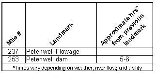
o Miles 237 - 253 (Petenwell Flowage) 23,040 acre Petenwell Flowage
is the second largest inland body of water in Wisconsin. Rough water
from wind and large boats can be hazardous to canoeists. Individuals
must use extreme caution because of the size, complexity, and constantly
changing conditions.
¢ Portages (see portage maps by clicking on the dam symbol)
o Mile 253 Petenwell dam - Take-out at a concrete base with wooden
steps and a wood canoe slide going up the dike for a 0.4 mile portage
to the landing below the dam (right)
- Landings suitable for take-out or put-in
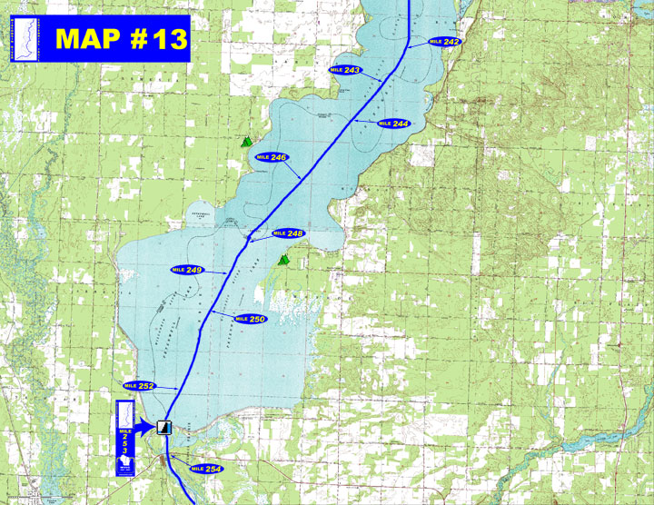
o Mile 242 - Apache Lane boat landing (left)
o Mile 243 - Barnum Bay boat landing (left)
o Mile 244 - Town of Monroe Park boat landing (left)
o Mile 246 - Juneau County Wilderness Park boat landing (right)
o Mile 248 - Adams County Petenwell Park boat landing (left) Armenia
boat landing (right)
o Mile 250 - Big Horn boat landing (left)
o Mile 252 - Van Kuren boat landing (left)
o Mile 254 - STH 21 Wayside boat landing (left)
(For a Wisconsin River Power Company informational map of Petenwell
Flowage showing additional access sites call 608-565-2500 or email
dmjohnson@integrysgroup.com)
o For a Wisconsin River Power Company informational map of Petenwell Flowage showing additional access sites go to http://www.wisconsinriverpower.com/recreation_petenwell.pdf)
- Camping
o Mile 246 Juneau
County - Wilderness Park with 140 sites & showers available
(right)
o Mile 248 Adams
County - Petenwell Park with 500 campsites, 90 boat slips &
heated restroom shower (left)
- Other amenities
o Mile 243 - Barnum Bay with boat landing, beach, picnic area, restrooms,
sailing center, and boater concessions (left)
o Mile 244 - Town of Monroe Park with boat landing, picnic area
and restrooms (left)
o Mile 246 - Juneau County Wilderness Park with boat landing, camping,
beach, picnic area, restrooms (right)
o Mile 248 - Adams County Petenwell Park (open year round) with
boat landing, camping, beach, picnic area, restrooms, and hiking
and cross country ski trails (left)
" Petenwell Veterans Park with beach, picnic area, restrooms,
and trails (right)
o Mile 252 - Van Kuren Landing with boat landing, beach, picnic
area, and trails (left)
o Mile 253 - Petenwell Powerhouse with boat landing, observation
tower, restrooms, boater concessions, and trail (right)
o Mile 254 - STH 21 Wayside with boat landing, restrooms, and picnic
area (left)
- Flow Information - For flow information on river flow below Petenwell go to http://www.wisconsinpublicservice.com/environment/hydrodata.aspx.
|

 on the map below for a aerial photographic detail of portage.