|
 -
General Description -
General Description
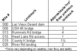
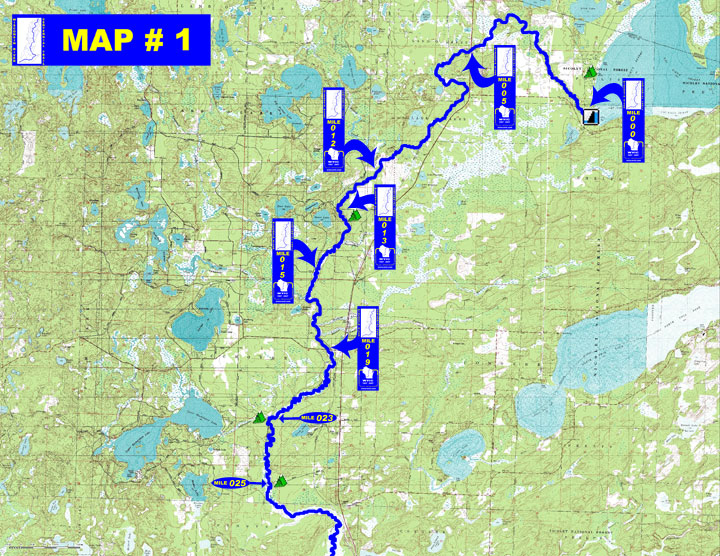
o Miles 000 - 005 (Lac Vieux Desert dam to USH 45) Upper 2 miles
are narrow but passable, typically encounter beaver dams and deadfalls
o Miles 005 - 013 (USH 45 to Rummels Rd) Velocity picks up but the
stream twists & turns, may need to walk your canoe through a
long stretch of low hazard rapids upstream of Portage Creek
o Miles 013 - 019 (Rummels Rd to Vilas County K) Flow increases
& river becomes wider
o Miles 019 - 025 (Vilas County K to River Rd landing) Floodplain
broadens and terrain becomes increasingly marshy
with occasional oxbows, current remains moderately fast
- Portages (see portage maps by clicking on the dam symbol)
o Mile 000 - Lac Vieux Desert dam - Short 100' portage around dam
" 3' diameter culvert on West Shore Rd (about 200 yd downstream
of the dam) portage across road
o Mile 000-002 Some beaver dams may need to be portaged
- Landings suitable for take-out or put-in
o Mile 000 Access to Lac Vieux Desert and tailwater at the dam portage
o Mile 005 USH 45 boat landing downstream of the bridge (left)
o Mile 013 Rummels Rd landing between vehicle & snowmobile bridges
(left)
o Mile 015 Heart Lake Rd undeveloped access (right)
o Mile 019 Boat landing at County K upstream of the bridge (left)
o Mile 025 River Rd landing (left)
- Camping
o USFS Campground on west shore of Lac Vieux Desert with 31 sites
o Mile 013 Vilas County - canoe campsite at Rummels Rd with shelter
& toilet (left)
o Mile 023 Vilas County - canoe campsite at Bucktabon Creek with
shelter & toilet (left bank of Buckatabon Creek on the right
side of the river)
o Mile 025 Vilas County - canoe campsite below River Rd with several
tables & toilet (left)
(Vilas County canoe campsites are free of charge for a 24 hr period
when traveling by watercraft, all have a picnic table & fire
ring, some have toilets provided but no water)
- Other amenities
o Mile 000 - Lac Vieux Desert Park with water, picnic area, &
restrooms at the dam
o Mile 005 - Historical marker & wayside with restroom &
picnic tables adjoin landing (left)
o Mile 012 - Rohr's Wilderness Tours
& private landing (left)
o Mile 019 - Conover ½
mile east on County K (left)
- Flow Information - None available, however trip accounts reveal
that if the staff gage in Lac Vieux Desert tailwater reads 0.6'
the water is just deep enough to float a canoe.
|


 -
General Description