|
 -
General Description -
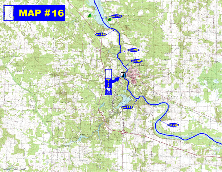
General Description
o Miles 282 - 289 (Upper Dells to Kilbourn dam) The river widens
into a 3-mile long lake with abundant fishing boats and is then
constricted by high sandstone walls into a narrow channel with heavy
traffic from tour boats, powerboats, and personal watercraft creating
hazardous conditions for canoeists. Channel splits around Blackhawk
Island, the recommended longer route being slower, more scenic and
safer.
o Miles 289 - 302 (Kilbourn dam to Pine Island State Wildlife Area)
Enter a swift tailwater area with strong currents and eddies for
the first few miles bordered by sandstone cliffs with sandy beaches.
Tour boats are also common in the Lower Dells down to the Rocky
Islands. The river then straightens out and offers wooded islands,
sandbars, and small secondary channels as it flows easterly through
a wider floodplain.
- Portages (see portage maps by clicking on the dam symbol)
o Mile 289 Kilbourn dam - Take-out goes up a gravel path to the
powerhouse entrance road for a ¼ mile portage to a parking
area with a steep path leading down to the tail water area (left)
- Landings suitable for take-out or put-in
o Mile 284 Private landing at River Bay Camping Resort & Marina
(right)
o Mile 287 Unimproved access on west side of Blackhawk Island (right)
o Mile 288 Crandals Bay municipal boat landing (left from river,
right side of bay)
o Mile 295 Fox Run Rd boat landing (left)
- Camping
o Mile 284 - Private campground - "River
Bay (608-254-7193)" (right)
" Private campground - "Holiday
Shores (608-254-2717)" (left)
o Camping is prohibited in state wildlife areas which includes the islands in the river that are part of Pine Island Wildlife Area.
- Other amenities
o Mile 288 through Mile 290 - Many businesses in Wisconsin
Dells, the Wisconsin
Dells Area Surrounding
Areas
o Mile 291 - River's
Edge Resort with canoe/kayak rentals and shuttles
- Flow Information - For flow information on river flow below Wisconsin Dells (Kilbourn) go to http://waterdata.usgs.gov/wi/nwis/uv/?site_no=05404000&PARAmeter_cd=00065,00060 or on this website go to Flow Forecasts under Wisconsin River /content.cfm?PageID=84&Cat=0
|