|
 -
General Description -
General Description
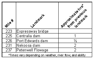
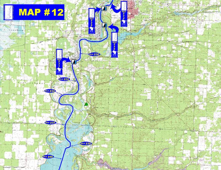
o Miles 223 - 225 (Expressway bridge to Centralia dam) Continue
through the city of Wisconsin Rapids going around several large
islands
o Miles 225 - 226 (Centralia dam to Port Edwards dam) The village
of Port Edwards lies on the right bank of the river
o Miles 226 - 231 (Port Edwards dam to Nekoosa dam) Just below the
dam is a rocky rapids before Nekoosa flowage begins. The city of
Nekoosa is on the right at the south end of the flowage.
o Miles 231 - 240 (Nekoosa dam to Petenwell flowage) Below the dam
the river meanders through shallow water sloughs to the beginning
of the 23,040 acre Petenwell Flowage where rough water from wind
and large boats can be hazardous to canoeists
- Portages (see portage maps by clicking on the dam symbol)
o Mile 225 Centralia dam - Take-out along the edge of a private
golf course and portage about ? mile to wide wooden steps at the
put-in that will lead you back to the river (left)
o Mile 226 Port Edwards dam - Take-out up a steep path to a wooded
trail for less than ½ mile long portage to a path that descends
to the put-in on a sandy shoreline (left)
o Mile 231 Nekoosa dam - Take-out is at the downstream end of Riverside
Park, follow the 1½ mile long portage through Nekoosa to
the put-in at another city park (right)
- Landings suitable for take-out or put-in
o Mile 224 Ben Hanson park boat landing (right)
o Mile 232 Nekoosa boat landing at the sewage treatment plant (right)
o Mile 234 Plank Hill boat landing (right)
o Mile 237 Wood County Day Use Area with boat landing at Devil's
Elbow (left)
o Mile 239 Third St boat landing (right) Chester Creek boat landing
(left)
o For a Wisconsin River Power Company informational map of Petenwell Flowage showing additional access sites go to http://www.wisconsinriverpower.com/recreation_petenwell.pdf)
- Camping
o Mile 235 Private campground - "Deer Trail Campground (715-886-3871)"
(left)
- Other amenities
o Mile 223 - Demitz Park with fishing area and accessible pier (left)
" Many businesses in Wisconsin
Rapids
o Mile 224 - Ben Hanson Park with boat landing, picnic areas with
shelters, playground, ball courts, restrooms, and bike trail (right)
o Mile 230 - Riverside Park with picnic pavilions, playground, and
restrooms (right)
" Some businesses in Nekoosa
(right)
o Mile 237 - Wood County Day-use area at Devils Elbow (east of the
river channel) with boat landing, restrooms, and picnic area (left)
o Mile 240 - Twin Lakes access (east of the channel) with beach,
picnic area, and hiking trail (left)
- Flow Information - For flow information on river flow below Centralia and Nekoosa go to http://www.cwpco.com/CWPCoDB/Daily_River_Report.aspx.
|


 -
General Description